Friday, July 26, 2013

4 Pass Loop: Aspen Colorado

Another week of foot clinic down and I was due for another trip to explore the Colorado mountains. The plan was to meet Spencer and Annie Weiler in the parking lot of Maroon Lake sometime during the night and then get up and run the 4 Pass Loop.

The Four Pass. We did it in a counterclockwise direction in the order of Buckskin Pass, Trail Rider Pass, Frigid Pass and Maroon Pass. 
The 4 Pass Loop is a 28 mile route that circumnavigates the mighty Maroon Bells (Maroon Peak and North Maroon Peak) which both are over 14,000ft. The rout climbs up and over four different passes that are over 12,000ft  while starting at only 9,600ft. The total elevation change is around 8,000ft. It is burly!


I left Denver around 7pm and after a quick stop to grab a cheap rain poncho I was on the road. Aspen is about a 3.5hr drive from Denver and it gets a little longer when everyone in Denver heads for the hills at about the same time. The drive there was awesome, climbing massive mountain passes under a full moon. I arrived in Aspen a little bit after midnight and was glad I had the wagon which allowed me to stretch out in the back.

Spence and Annie were parked next to me when I awoke and we preped for the run. Annie had sprained her ankle the week before and opted out on this adventure. Spence and I were on the trail around 6:45am.

Maroon Lake. 
The sights were absolutely unbeatable and these pictures don't give it justice at all.

View from the top of pass #1, Buckskin Pass. We came up the canyon to the left. 

Buckskin Pass. Our next objective was the lake below the gray mountain rang in the middle. 


Snowmass Lake!
View from top of pass #2, Trail Rider Pass, looking down at Snowmass Lake. 
Spence heading down off of Trail Rider Pass. 
Looking down from pass #3, Frigid Pass. We cam up from way down this canyon to the left. 

View from top of pass #4, Maroon Pass. We came up the left canyon and are headed down the right canyon. 
Notice the super rocky train. Below there you can the lake that I thought was the finish. Wrong, that one is Crater Lake and I finish at Maroon Lake. 
Spence didn't bring his Excedrin and ended up getting a brutal headache due to the altitude. He had to dig deep. He used this run as a training run for the Wasatch 100 mile race he is doing in September. In the condition I was in I couldn't even dream of doing another 72 miles of similar terrain and I beat him to the end by 19 minutes. I wish him the best in his gargantuan undertaking. A 100 miler may be in my future, someday......not today.

Reward.

During the drive and run I was able to get in a few awesome podcasts that covered a whole heap of topics such as cash or curse scams, reality TV show of a one way trip to Mars, Good Science vs Bad Science according to TEDx, The New Testament and tons of other things. Running and driving are great times to learn and think.

Colorado is providing some stellar adventures!

The STATS:
Distance: 28miles
Elevation climbed: ~8,000ft
Time: 8hrs 25min
Calories consumed: CliF Energy Gel x2, Power Gel x1, Nature Valley Granola Bar x2, Clif Bar x1, Clif Shot Bloks x1 pkg. Total calorie count of approx 1,120.
Water consumed: approx 3 Liters.

Sunday, July 14, 2013

Longs Peak, RMNP and Gear Comments


I attempted to run up Longs Peak this weekend via the 15mile RT Keyhole rout. I say attempted because while my heart rate was elevated the entire time I wasn't necessarily "running". Longs Peak is in Colorado's Rocky Mountain National Park (RMNP) and is 14,259ft high. It was the 3rd 14er I have been able to summit. The mountain has got some world famous climbing routs on it's east face known as "The Diamond". I have hopes of getting up one of those routs this season but time will tell.

The "route brochure" published by the National Park service stated:

Begin your climb no later than 3 a.m. to be off the summit early in the day. Time for the 15-mile round-trip averages 10 to 15 hours.
The Keyhole Route is NOT a hike! It is a climb that crosses enormous sheer vertical rock faces, often with falling rocks, requiring scrambling, where an unroped fall would likely be fatal. The route has narrow ledges, loose rock, and steep cliffs. The terrain requires good route-finding and scrambling skills. Use caution, as injuries requiring rescue are very dangerous and take many hours, if not days, to evacuate.

I drove up from Denver area and arrived at the trail head around 7:30am. I was hoping to get an earlier start due to the all too common afternoon storms that roll through alpine areas like this, but the gravity of my bed didn't allow me to get up until 5:15am.  I hit the trail around 7:45. The first 20-30 minutes of every run are, in my opinion, one of the more difficult periods of every run and starting at 9,400ft doesn't help. [**Physiology Review: This makes sense because going from resting to jogging instantly causes the muscles to start consuming more oxygen and producing more carbon dioxide. This rapid decrease in oxygen forces the cells to transition to anaerobic respiration which allows the body to create energy without oxygen. The process is less effective than aerobic respiration (with oxygen) and produces lactic acid. Lactic acid makes you feel crappy. It takes the body awhile to get triggered by the increased amounts of carbon dioxide in the blood, causing an increase in cardiac and respiratory function. Until the body gets back to equilibrium you feel like you are totally out of shape and shouldn't be attempting what you have just started.] 

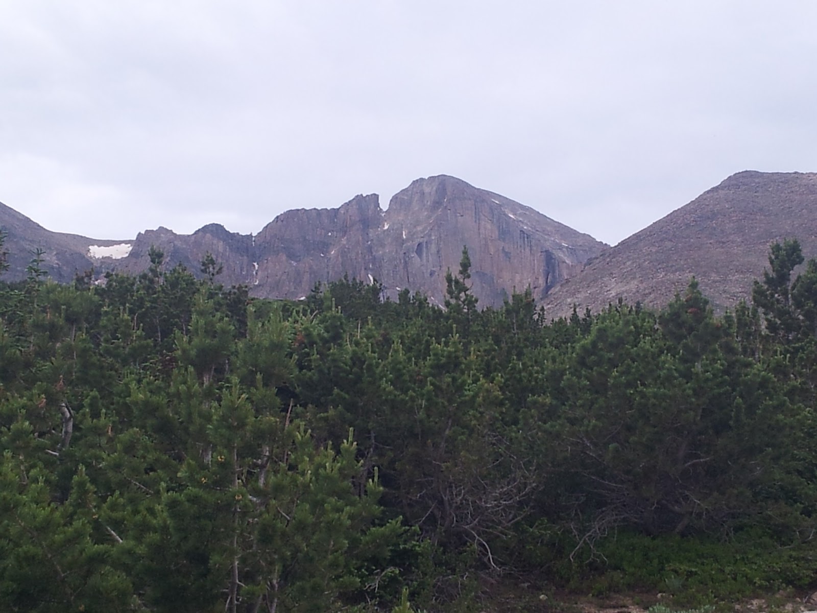
The route gets above the tree line fast and you have full view of the east face only a few miles in. As I moved up the trail I did as I usually do and listened to podcasts. This adventure had me listening to "The Skeptic's Guide to the Universe" which was absolutely mind stimulating.  I worked my way up through the "keyhole" and onto the backside where I followed bullseyes painted on the rocks through the "The Ledges", "The Trough", "The Narrows" and "The Homestretch". The route followed various broad ramps and ledges across an exposed face, headed up a steep rocky gully, traversed another series of ramps and then headed up a smoother face to the summit. There was a decent amount of people on the route that I hoofed past on my way up and down, some even with helmets and ice axes. It was a great climb/run!
First sighting of Longs.
Above the tree line. 
"The Ledges". Notice the bulls-eye on the left. 
Heading up "The Trough" section.


"Narrows" section. 
Distorted panorama from the top. 
Summit pic.
I reached the summit, in around 2:30, a few minutes behind a local runner who I had passed at the start of the trail, that later passed me just before the Keyhole. He mentioned that he runs the route all the time which made me feel somewhat accomplished. [That feeling of accomplishment was later completely dashed when I learned that the fastest known time(FKT), car to car, was 1:56:46 by Andy Anderson with a 1:14 ascent, the same guy that owns the FKT for the Grand Teton]. About half the way down I started to feel the elevation a little and had to back off. I was starting to get a little "stumbly" which could easily end my mountain play season with one misstep. The Colorado native passed me and I just tried to maintain control and finish it out. I reached the TH with a total time of approx 4:40. I was happy with it.

Stats:
Distance: 15miles
Time: Approx 4hrs 40min
Summit time: Approx 2hrs 30min
Elevation Gain: 5,100ft

During this outing I was also able to check out Rocky Mountain National Park(RMNP). It is a beautiful place, reminding me a lot of Glacier National Park with roads that would put you high up on the mountain tops. I met up with a fellow podiatry colleague and we did some hikes and outran a few rain storms. Here are a few pictures.

Up above a high mountain lake in RMNP.


Stupid mountain fun.....

Quick comments on some gear:

NATHAN  HLP #020 Hydration Vest


This was my first time using a running vest. I got it as an early birthday present and loved it! Here are a few reasons why:

  1. The name "NATHAN" is a strong name. 
  2. The bladder opens completely so it can dry out. 
  3. The mouthpiece hooks into the sternum strap so it doesn't flop around. 
  4. The bag rides high on your back and secures down well so that it hardly even bounces with 2L of water and gear stored in it. 
  5. I was able to fit a running jacket and base layer in it. 
  6. The two pockets on the front straps are situated so they ride in your arm pits, keeping the contents dry when it rained. 
  7. The front strap pockets allow easy access to my camera/phone (to take quick pictures, answer phone calls or switch podcasts) and power gels without stopping.
  8. The way the pack rode didn't restrict my breathing. It didn't restrict chest cavity expansion. 
Great pack!

Brooks Pure Grit (initial model)


The time is nearing for me to get some new shoes.I have loved my Brooks Pure Grit trail shoes and have probably put around 1000 miles on them. The soles probably weren't the best to be scaling mountains with but they did the trick. I will likely replace them with the new model of the Pure Grit which has a more aggressive sole. But hopefully I can get a few more miles out of them!

Wednesday, July 10, 2013

Climbing Vedauwoo and Greyrock


Vedauwoo Wyoming is about an hour north or Fort Collins Colorado.  I had the opportunity to go up there climbing with my good friends Brody and Kiley. Spending the month here in Denver has been great because it has all of this new stuff to check out and play on. When I pulled out of Oakland a few weeks ago to head over Kimber and I were in a hurry and I ended up leaving my entire climbing bag in our living room!!! Luckily I had thrown Kimbers harness and my climbing helmet in a different bag but I ended up having to spend the weekend climbing in some of Brody's old shoes that had a hole in the toe and in Kimbers women's size small harness. I made it work.


We started the day off with a 5.7 mountainproject "classic" off-width rout called "Mother 1". It was a deep groove single pitch rout. None of us had brought tape for our hands and we regretted it big time while climbing. I decided to take the lead. Off-width is defined in wiki as "a crack that is two wide for effective hand or foot jams, but is not as large as a chimney." Translation, rating mean little because they are freaking hard and you have to jam all different parts of your body into the crack to get up the thing. I will let the pictures tell the story of how it went. By the end I had ripped up hands, shoulders and ankles. Not sure how "classic" it was but I still had fun.


Kiley making her way up.
The second climb of the day was  up another single pitch 5.7 low angle off-width climb called Edward's Crack. It had a fun start, went into a low angle shallow groove and then finished with pulling a roof which was pretty fun. Brody took the lead of this one, Kiley followed and I brought up the rear.

Edwards Crack is the vertical arm of the obvious cross on the left face. 

Greyrock is up Poudre Canyon about 30min outside of Fort Collins Colorado. Getting to it required an hour approach hike. Brody and I took it at a good clip and were a bit surprised to see that it even hiking that fast we didn't beat the mountainproject time. This rout had 4 pitches and went at 5.8. Brody took the first pitch which had the crux move requiring him to pull a roof off the ground. He then worked his way up through a maze of cracks to the belay. My lead was basically a walk up with another fun roof move that had a huge hero hold making it more fun that scary. The last two pitches were on the verg of us just freeing them because they were so easy. It was great to get out anyways. There is something about being in the mountains with friends that makes me feel good about life....real good.


Me on pitch 2. 

Thursday, July 4, 2013

Colorado 14ers #1 & 2: Gray's Peak and Torrey's Peak


View from the top of Grays. In the distance to the left you can see Torreys Peak. 
I got out today for my first run in the hills of Colorado and decided to go after two 14ers that were close to each other; Grays Peak(14,278ft) and Torreys Peak(14,275ft). The trailhead was at 11,280ft which is high compared to the highest mountain in The East Bay were I usually run, Mt. Tamalpais (2,574ft), or even the Wasatch Range's higher peaks such as Lone Peak (11,253ft). It was a beautiful run. I was interested to see how I could do at elevation like this, as I have never been that high before. It was a push to get to the top and the trail was pretty busy so I had to pass a lot of people both going up and down. I was tired and felt the lack of oxygen for sure but felt that I held up well. Below are pictures and stats.


View to the North off of Torreys Peak. 
Stats:
Mileage RT: 8.25
Elevation Gain: 3600ft
Elapsed Time: Approx 2:45. 

I am diggin Colorado.