Sunday, September 28, 2014

Central Cascades Alpine Lakes Wilderness: Chair Peak (almost)

A enjoyed my morning after running in Olympic NP and by about noon I was itching to go check out something else before picking Kimber up at the airport that night. I ended up shooting for a 4th class scramble up Chair Peak (6238ft). The peak is a popular mixed winter ascent but looked promising for a rock ascent.

Getting there only took about an hour and I was at the busy trail-head by 3:30pm. The trail I started on went towards Snow Lake, which is where I assume most of the people were headed. I dodged off the main trail at approximately 1.5 miles towards Source Lake, after which I scrambled a huge bolder field and ended up making a few moves to a small face where I encountered another bolder field. There I ran into two climbers coming off of Chair Peak.

Boulder field above Source Lake. 


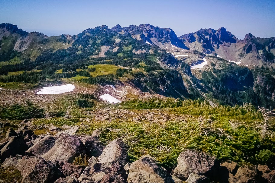
I continued up past a small snow field where I had to choose to go up a gully on the right or left. I chose left and headed up a 4th class/low 5th class gully to top out and on a knife edge ridge. The rock was quite chossy(loose) forcing me to make every move with caution. I climbed up a few false summits on the sharp ridge to find myself separated from Chair Peak by a huge notch. After taking in my surroundings I bailed due to rock conditions and limited daylight as well as the fact that I was solo. Down climbing is never really fun but I made it back down safely and after a bit of bushwhacking I found my way back to a trail and after passing by Snow Lake was on my way back to the car.

Knife edge, chossy ridge.

View of Chair Peak from my false summit on the wrong side of the notch...
It was a quick trip but well worth it to check out the area a bit. There are endless peaks and trails in the Cascades! So much to explore! Apparently that area is also a common back-country ski area. My mind is salivating!

Snow Lake from above. 

Snow Lake.

Stats(9/21/14)
Distance: 8.5miles
Time: 3hrs 30min
Elevation Gain: 3235ft


Olympic National Park: 7 Lakes Basin Loop

Thinking that it might be my last chance to get to the hills for awhile do to the infamous rains coming and an upcoming stint of repeated weekend call, I decided to pull a quick solo trip to Olympic National Park. Kimber was on her bazillianth trip back to California shooting a wedding, so I was rolling solo. I found a beautiful multi-day backpacking loop with high ratings online called "7 Lakes Loop" and hit the road Friday night.

View of Olympic NP from Hurricane Ridge at sunset. 
I rolled into Port Angeles around 11pm exhausted. I had been up that morning since 4:45am in order to get Kimber at the airport before arriving at the hospital for our pre-surgery meeting. The guy at the gas station directed me to a small pullout just outside of town that I could "probably" sack-out at. I got settled and was out cold under the stars next to my car. I awoke around 12:30am to a police officer explaining that I wasn't allowed to sleep there. I was in that deep kind of sleep that leaves you  barely knowing where you are when you awake and your head ringing. After doing my best to answer the cops questions while he flashed his million lumen flashlight in my confused face, he recommended that I go the "Wally World" parking lot, but then commented that if I didn't feel like it was safe for me to drive then "it is what it is", and left. I took that as permission to stay and rolled over.

Lake Crescent.
Completed the loop clockwise. 
Heart Lake.
The next morning I drove along the north side of the park past Lake Crescent which was amazing with the morning sun and surrounding steep mountains. I headed up to the trail-head near the Sol Duc Hot Springs, geared up and hit the trail. The first section of the run was about 8 miles of steady climbing (3100ft) that started in thick pines and opened up at the top to a small lake and eventually to the ridge-line where I was rewarded with a beautiful view of Mt. Olympus. It was breathtaking!

Headed down toward Cat Basin. 
Mt. Olympus from High Divide. 

Trucking up High Divide with a backpacker in the background. 
At the top I made the decision to add a few miles be checking out Cat Basin which dropped me down to another lake and gave me some more epic views of Olympus. Half way down I decided that it wasn't worth it and turned around. I climbed up the High Divide ridge-line running past "7 Lakes Basin" which was also gorgeous, and eventually topped out on Bogacheil Peak(5475ft). I then dropped back down, following miles of tasty single track surrounded by views of the basin and surrounding area and eventually back to the trail head. The trail was pretty busy most of the way with backpackers further out and multiple day hikers closer to the trail-head. Beautiful trail.

Seven Lakes Basin. 

Awesome single track. 


I felt pretty good this run. During the run I pounded a PB&J and Nutella sandwich as well as a few granola bars.

After reaching the car I headed back down to Crescent Lake to a nice day picnic area that was empty. I jumped into the lake to clean off and took a nap for a few hours after trying to study some podiatry material and eating some lentil soup (just what I found in the cupboard). That evening I drove up to Hurricane Ridge and ate my dinner (a can of chicken and another of pineapple). The views were pristine with the fall colors beginning to show! I used my map to try to figure out the best way to access some of the peaks looming in the distance for future adventures. I debated on sticking around and running something the next day but my comfortable bed, morning bacon and coffee was calling my name. I made the 3 hour drive home and called it an awesome trip. Yeah for Washington!

Mt Olympus from Hurricane Ridge while eating my dinner at sunset. 
Stats (9/20/14)
Distance: Approx 22 miles
Time: 5 hrs 15min
Elevation climbed: Approx 4500ft


Mt. Rainier: Mowich Loop

From our new home in Tacoma WA we have a beautiful view of Mt. Rainier. Often times we grill dinner while watching the mountain aglow with the sunset rays. It just taunts me.

View from Tacoma. 

I finally had a day to get away from the craziness of being a podiatry intern and was able to go check out the Mowich Loop which includes a small portion of the famous Wonderland Trail. The Wonderland trail is a popular backpacking loop that circumnavigates Mt. Rainier and makes a burly 93 mile ultra-run.


Access to the Mowich loop is via a painful 10 mile drive down a dirt road which I thought would deter people. I was wrong. I rolled up to the trail-head in the late morning to find the parking area full. The run was beautiful. Single track the entire way! I passed hoards of people for about the first mile while running next the the lake and then the numbers started to drop after passing the turn off to the Tolmie Peak lookout.

After reaching Ipsut Pass the trail dropped 2500ft over the next 3.5 miles to follow the Carbon River. From the river bottom I saw another pair of runners who were also completing the loop but heading in the opposite direction. I also had a random hiker jokingly ask me if I was high. Good one, buddy. I ran over the suspension bridge and the climb was on. Over the next 8 miles I climbed 3,800 feet. During the climb I was rewarded with a few views and eventually topped out at an amazing view of the northwest side of Rainier. I took a few minutes to take it all in. Awesome.

Carbon River and Rainier. 

Suspension bridge over Carbon River. 

Looking back during the end of m 3800ft ascent from Carbon River.
 From there it was a decent back down and around to the other side of Mowich Lake. The trail was busy with people headed up to the incredible view.

Miles of beautiful single track dropping back down and around to Mowich Lake. 

Below Observation (right) and Echo (left) Rock with Ranier's northwest face towering behind. 

Spray Park, a little detour a few miles before finishing the loop. 
Great run.  Liking Washington. 

Stats(9/7/14)
Distance: 17miles
Time: 4hrs 36min
Elevation Gain: 4823ft

View of Rainier's west side.